Atlantic Currents Gouache on paper 30 x 42 cm 2019
I look for the hidden and new topographies that exist in our landscape. I look because I have a theory. This theory is that these hidden or invisible new, and proliferating, signal topographies hold us hostage, thus threatening how we live and operate in our environment, even threatening existence as we know it. The latter may seem extreme, but identifying potential existential risks, and thinking about mitigation strategies, is far better than suffering irredeemable circumstances. The risk revealed in these new topographies is the insidious nature of connected and networked systems. While these systems do deliver positive outcomes, there is an underbelly. Here, it is important to think about Paul Virilio's statement “no technology has ever been developed that has not had to struggle against its own specific negativity”.[1]
The underbelly of networked and connected systems includes the militarisation and militarise-ability of signals. Designated military networking is one thing. But, security and policing activities, including monitoring such things as cyber terrorism, transnational crime and border security, are increasingly militarised by technologies and devices that are dual-use. This is compounded by the ability of the militarised system, or those with mal-intent, to appropriate civilian technologies, systems and devices into their domains. A simple example is accessibility to mobile phones and the plethora of data they deliver. Surveillance is the lining of the underbelly!
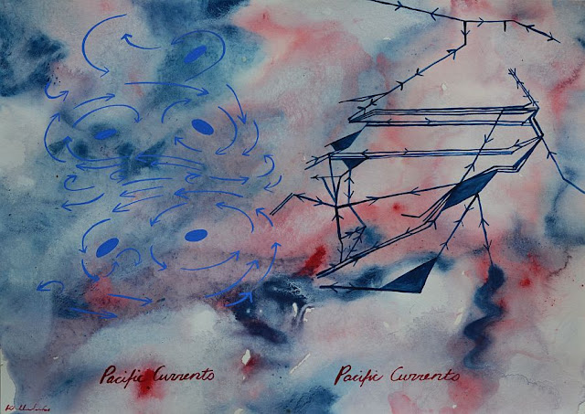
Atlantic Currents and Pacific Currents
Atlantic Currents and Pacific Currents depict sea currents on the left of the image, and undersea cabling maps on the right. Both relay elements of landscape, one is natural, the other is not. Both landscapes influence how we live. Sea currents influence water temperatures, fishing, maritime activities and so on. Undersea cables enable communication, the internet and more. Multi-Mission (bottom) depicts the signalling the enables the operation of militarised airborne drones. Signals travelling at near light speed are conducted via undersea cabling from Creech Airbase in the Nevada Desert, to Ramstein Airbase in Germany, to satellites and then to the drones. The drones sensors capture new data that is delivered back along the connected system.
These three paintings are part of a larger group of works on paper and oil paintings, where I attempt to expose the occupation of landscape, from subterranean/undersea to land, to the sky and into space. It is a volumentric kind of occupation - a colonisation that enables a persistent readiness for offensive and defensive action. The invisible part of the Derek Gregory's "everywhere war".(2)
Can you see why I think it indicates an existential risk? Yes, risk lies in the development of, for example, autonomous weapons. But, signals are the ubiquitous enablers.
I could write more, but I will leave you to look and think.
Cheers,
Kathryn
[2] Derek Gregory, “The Everywhere
War,” The Geographical Journal 177,
no. 3 (2011): 238-50.
Pacific Currents Gouache on paper 30 x 42 cm 2019
Multi Mission Gouache on paper 30 x 42 cm 2019


No comments:
Post a Comment